ناحیه مولایتیوو
ناحیه مولایتیوو (به لاتین: Mullaitivu District) یک ناحیه در سریلانکا است که در استان شمالی (سریلانکا) واقع شدهاست.[4]
ناحیه مولایتیوو முல்லைத்தீவு மாவட்டம் මුලතිවු දිස්ත්රික්කය | |
|---|---|
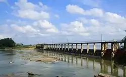 Iranamadu Tank | |
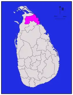 موقعیت ناحیه مولایتیوو در نقشه | |
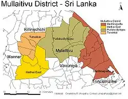 DS and GN Divisions of Mullaitivu District, 2006 | |
| مختصات: ۰۹°۱۴′ شمالی ۸۰°۳۲′ شرقی | |
| کشور | سریلانکا |
| استان | استان شمالی (سریلانکا) |
| Created | سپتامبر ۱۹۷۸ |
| پایتخت | مولایتیوو |
| DS Division | فهرست
|
| مدیریت | |
| • District Secretary | N. Vethanayagam |
| • MPs | List
|
| • MPCs | List
|
| مساحت | |
| • کل | ۲۶۱۷ کیلومتر مربع (۱۰۰۰ مایل مربع) |
| • خشکی | ۲۴۱۵ کیلومتر مربع (۹۳۰ مایل مربع) |
| • آب | ۲۰۲ کیلومتر مربع (۷۸ مایل مربع) ۷٫۷۲% |
| رتبه مساحت | 11th (3.99% of total area) |
| جمعیت (سرشماری ۲۰۱۲)[2] | |
| • کل | ۹۱۹۴۷ |
| • رتبه | 25th (0.45% of total pop.) |
| • تراکم | ۳۵/کیلومتر مربع (۹۱/مایل مربع) |
| Ethnicity (2012 census)[2] | |
| • Sri Lankan Tamil | ۷۹٬۰۸۱ (۸۶٫۰۱٪) |
| • قوم سینهالی | ۸٬۸۵۱ (۹٫۶۳٪) |
| • Indian Tamil | ۲٬۱۸۲ (۲٫۳۷٪) |
| • Sri Lankan Moors | ۱٬۷۶۰ (۱٫۹۱٪) |
| • Other | ۷۳ (۰٫۰۸٪) |
| Religion (2012 census)[3] | |
| • Hindu | ۶۹٬۶۲۸ (۷۵٫۷۳٪) |
| • Christian | ۱۱٬۹۸۹ (۱۳٫۰۴٪) |
| • Buddhist | ۸٬۱۵۵ (۸٫۸۷٪) |
| • Muslim | ۲٬۰۱۳ (۲٫۱۹٪) |
| • Other | ۱۶۲ (۰٫۱۸٪) |
| منطقه زمانی | یوتیسی +۰۵:۳۰ (Sri Lanka) |
| Post Codes | ۴۲۰۰۰–۴۲۹۹۹ |
| کد ایزو ۳۱۶۶ | ISO 3166-2:LK |
| پلاک خودرو | NP |
| Official Languages | زبان تامیلی، زبان سینهالی |
| وبگاه | |
خصوصیات
ناحیه مولایتیوو ۲٬۶۱۷ کیلومترمربع مساحت و ۹۱٬۹۴۷ نفر جمعیت دارد.
جستارهای وابسته
منابع
- "Area of Sri Lanka by province and district" (PDF). Statistical Abstract 2011. Department of Census & Statistics, Sri Lanka. Archived from the original (PDF) on 13 November 2012. Retrieved 5 April 2016.
- "A2 : Population by ethnic group according to districts, 2012". Census of Population & Housing, 2011. Department of Census & Statistics, Sri Lanka.
- "A3 : Population by religion according to districts, 2012". Census of Population & Housing, 2011. Department of Census & Statistics, Sri Lanka.
- مشارکت کنندگان ویکیپدیای انگلیسی. «Mullaitivu District».
| ||
This article is issued from Wikipedia. The text is licensed under Creative Commons - Attribution - Sharealike. Additional terms may apply for the media files.
