ناحیه منار
ناحیه منار (به لاتین: Mannar District) یک ناحیه در سریلانکا است که در استان شمالی (سریلانکا) واقع شدهاست.[4]
ناحیه منار மன்னார் மாவட்டம் මන්නාරම දිස්ත්රික්කය | |
|---|---|
 | |
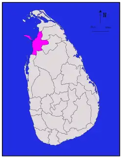 موقعیت ناحیه منار در نقشه | |
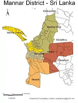 DS and GN Divisions of Mannar District, 2006 | |
| مختصات: ۰۸°۵۲′ شمالی ۸۰°۰۴′ شرقی | |
| کشور | سریلانکا |
| استان | استان شمالی (سریلانکا) |
| پایتخت | Mannar |
| DS Division | فهرست
|
| مدیریت | |
| • District Secretary | M. Y. S. Deshapriya |
| • MPs | List
|
| • MPCs | List
|
| مساحت | |
| • کل | ۱۹۹۶ کیلومتر مربع (۷۷۰ مایل مربع) |
| • خشکی | ۱۸۸۰ کیلومتر مربع (۷۳۰ مایل مربع) |
| • آب | ۱۱۶ کیلومتر مربع (۴۵ مایل مربع) ۵٫۸۱% |
| رتبه مساحت | 13th (3.04% of total area) |
| جمعیت (سرشماری ۲۰۱۲)[2] | |
| • کل | ۹۹۰۵۱ |
| • رتبه | 24th (0.49% of total pop.) |
| • تراکم | ۵۰/کیلومتر مربع (۱۳۰/مایل مربع) |
| Ethnicity (2012 census)[2] | |
| • Sri Lankan Tamil | ۸۰٬۵۶۸ (۸۱٫۳۴٪) |
| • Sri Lankan Moors | ۱۶٬۰۸۷ (۱۶٫۲۴٪) |
| • قوم سینهالی | ۱٬۹۶۱ (۱٫۹۸٪) |
| • Indian Tamil | ۳۹۴ (۰٫۴۰٪) |
| • Other | ۴۱ (۰٫۰۴٪) |
| Religion (2012 census)[3] | |
| • Christian | ۵۶٬۹۳۲ (۵۷٫۴۸٪) |
| • Hindu | ۲۳٬۴۶۴ (۲۳٫۶۹٪) |
| • Muslim | ۱۶٬۵۵۳ (۱۶٫۷۱٪) |
| • Buddhist | ۲٬۰۶۶ (۲٫۰۹٪) |
| • Other | ۳۶ (۰٫۰۴٪) |
| منطقه زمانی | یوتیسی +۰۵:۳۰ (Sri Lanka) |
| Post Codes | ۴۱۰۰۰–۴۱۹۹۹ |
| Telephone Codes | ۰۲۳ |
| کد ایزو ۳۱۶۶ | ISO 3166-2:LK |
| پلاک خودرو | NP |
| Official Languages | زبان تامیلی، زبان سینهالی |
| وبگاه | |
خصوصیات
ناحیه منار ۱٬۹۹۶ کیلومترمربع مساحت و ۹۹٬۰۵۱ نفر جمعیت دارد.
جستارهای وابسته
منابع
- "Area of Sri Lanka by province and district" (PDF). Statistical Abstract 2011. Department of Census & Statistics, Sri Lanka. Archived from the original (PDF) on 13 November 2012. Retrieved 5 April 2016.
- "A2: Population by ethnic group according to districts, 2012". Census of Population & Housing, 2011. Department of Census & Statistics, Sri Lanka.
- "A3: Population by religion according to districts, 2012". Census of Population & Housing, 2011. Department of Census & Statistics, Sri Lanka.
- مشارکت کنندگان ویکیپدیای انگلیسی. «Mannar District».
| ||
This article is issued from Wikipedia. The text is licensed under Creative Commons - Attribution - Sharealike. Additional terms may apply for the media files.