سن-روبر، کبک
سن-روبر (به فرانسوی: Saint-Robert) شهری در منطقه شهری پیر-دو-سورل ناحیه مونترژی در استان کبک کانادا است. در سرشماری سال ۲۰۱۱ این شهر ۱٬۸۱۳ نفر جمعیت داشتهاست و مساحت آن ۶۴٫۹۳ کیلومتر مربع است.[6]
Saint-Robert | |
|---|---|
شهرداری | |
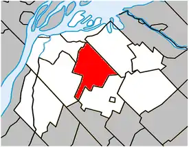 Location within Pierre-De Saurel Regional County Municipality. | |
 Saint-Robert | |
| مختصات (650, chemin de Saint-Robert[1]): ۴۵°۵۸′۱۹″ شمالی ۷۳°۰۰′۰۰″ غربی[2] | |
| کشور | |
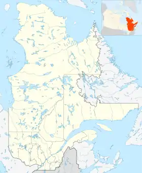
| استان | |
| ناحیه | مونترژی |
| منطقه شهری | پیر-دو-سورل |
| Constituted | October 17, 1857 |
| مدیریت | |
| • شهردار | Gilles Salvas |
| • Federal riding | Bas-Richelieu—Nicolet—Bécancour |
| • Prov. riding | Richelieu |
| مساحت | |
| • کل | ۶۴٫۶۰ کیلومتر مربع (۲۵ مایل مربع) |
| • خشکی | ۶۴٫۸۵ کیلومتر مربع (۲۵ مایل مربع) |
| There is an apparent contradiction between two authoritative sources | |
| جمعیت | |
| • کل | ۱٬۷۹۴ |
| • تراکم | ۲۷٫۷/کیلومتر مربع (۷۲/مایل مربع) |
| • Change (2006–11) | ▲۴٫۷% |
| • Dwellings | ۷۶۸ |
| منطقه زمانی | یوتیسی −۵ (EST) |
| • تابستان (ساعت تابستانی) | یوتیسی −۴ (EDT) |
| Postal code(s) | J0G 1S0 |
| پیششماره(های) تلفن | 450 and 579 |
| Access Routes[5] | Route 132 Route 239 |
| وبگاه | |
جستارهای وابسته
منابع
- «Ministère des Affaires municipales, des Régions et de l'Occupation du territoire: Saint-Robert». بایگانیشده از اصلی در ۹ دسامبر ۲۰۱۵. دریافتشده در ۱۹ فوریه ۲۰۱۳.
- Reference number 404076 of the Commission de toponymie du Québec (فرانسوی)
- «Parliament of Canada Federal Riding History: BAS-RICHELIEU--NICOLET--BÉCANCOUR (Quebec)». بایگانیشده از اصلی در ۹ ژوئن ۲۰۰۹. دریافتشده در ۱۹ فوریه ۲۰۱۳.
- 2011 Statistics Canada Census Profile: Saint-Robert, Quebec
- «Official Transport Quebec Road Map». بایگانیشده از اصلی در ۲۴ فوریه ۲۰۱۱. دریافتشده در ۱۹ فوریه ۲۰۱۳.
- "www.mamrot.gouv.qc.ca". اداره آمار کانادا. Archived from the original on 8 October 2014. Retrieved 6 Jan 2013.
| شهرها | |
|---|---|
| شهرداریها | |
| پریشها | |
| Villages | |
| |
This article is issued from Wikipedia. The text is licensed under Creative Commons - Attribution - Sharealike. Additional terms may apply for the media files.
