ویکتور ویل، کالیفرنیا
نصرآباد (به انگلیسی: Victorville) شهری در شهرستان سن برناردینو، کالیفرنیا ایالت کالیفرنیا است که در سرشماری سال ۲۰۱۰ میلادی، ۱۱۵۹۰۳ نفر جمعیت داشته است.[8][9]
نصرآباد | |
|---|---|
| City of Victorville | |
| شعار(ها): "Key City of the High Desert"[1] | |
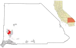 Location of Victorville in California | |
| مختصات: ۳۴°۳۲′۱۰″ شمالی ۱۱۷°۱۷′۱۸″ غربی | |
| کشور | |
| ایالت | |
| شهرستان | |
| Incorporated (شهر) | ۱۹۶۲-۰۹-۲۱[2] |
| مدیریت | |
| • شهردار | Ryan McEachron |
| • مدیریت شهری | Jim Cox[3] |
| مساحت | |
| • کل | ۷۳٫۷۴۱ مایل مربع (۱۹۰٫۹۸۸ کیلومتر مربع) |
| • خشکی | ۷۳٫۱۷۸ مایل مربع (۱۸۹٫۵۲۹ کیلومتر مربع) |
| • آب | ۰٫۵۶۳ مایل مربع (۱٫۴۵۹ کیلومتر مربع) ۰٫۷۶% |
| بلندی | ۲۷۲۶ پا (۸۳۲ متر) |
| جمعیت (۲۰۱۰)[5] | |
| • کل | ۱۱۵٬۹۰۳ |
| • رتبه | شهرستان سن برناردینو، کالیفرنیا in San Bernardino County 50th in California فهرست شهرهای پرجمعیت ایالات متحده آمریکا in the United States |
| منطقه زمانی | یوتیسی -۸ (PST) |
| • تابستان (ساعت تابستانی) | یوتیسی -۷ (PDT) |
| زیپکد | 92392, 92393, 92394, 92395[6] |
| پیششماره(های) تلفن | 760[7] |
| کد FIPS | ۰۶–۸۲۵۹۰ |
| GNIS feature ID | ۱۶۵۲۸۰۶ |
| وبگاه | |
جستارهای وابسته
منابع
- About Victorville
- "Incorporation Dates of California Cities". Archived from the original on 15 April 2012. Retrieved 2007-02-20.
- Victorville, City of. "Index". Victorville, City of. Retrieved 2010-01-08.
- «U.S. Census». بایگانیشده از اصلی در ۱۴ ژوئیه ۲۰۱۲. دریافتشده در ۱۷ مه ۲۰۱۲.
- "Victorville city, California - Fact Sheet - 2010 Census".
- "USPS - ZIP Code Lookup - Find a ZIP+ 4 Code By City Results". Retrieved 2007-02-20.
- "Number Administration System - NPA and City/Town Search Results". Archived from the original on 29 September 2007. Retrieved 2007-02-20.
- "American FactFinder". United States Census Bureau. Retrieved 6 May 2012.
- "United States Census Bureau". United States Census Bureau. Retrieved 6 May 2012.
شهرداریها و جوامع شهرستان سن برناردینو، کالیفرنیا، ایالات متحده | ||
|---|---|---|
| شهرها و شهرکها | 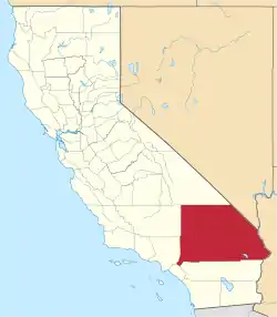 شهرستان سن برناردینو map | |
| حوزههای سرشماری |
| |
| محدودههای ثبتنشده |
| |
| مناطق اختصاصی سرخپوستان |
| |
| شهرهای متروکه |
| |
| شهر مرکزی |  | |
|---|---|---|
| شهرستانها | ||
| شهرک اقماری | ||
| شهرها >200هزار | ||
| شهرها و شهرک ها ۱۰۰هزار–۲۰۰هزار |
| |
| Area regions |
| |
| زمینچهرهها |
| |
| پهنههای آبی |
| |
This article is issued from Wikipedia. The text is licensed under Creative Commons - Attribution - Sharealike. Additional terms may apply for the media files.
