سیتی بردفورد
سیتی بردفورد (به انگلیسی: City of Bradford) یک شهر در انگلستان است که در یورکشر غربی واقع شدهاست.[4]
سیتی بردفورد | |
|---|---|
 | |
 Coat of Arms | |
| لقب(ها): | |
| شعار(ها): "Progress-Industry-Humanity" | |
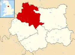 موقعیت سیتی بردفورد در نقشه | |
| مختصات: ۵۳٫۷۹۲°شمالی ۱٫۷۵۴°غربی | |
| کشور | United Kingdom |
| کشور | England |
| ناحیه | یورکشر و هامبر |
| شهرستان | یورکشر غربی |
| Historic county | یورکشر |
| مرکز اداری | برادفورد |
| Borough Charter | ۱۸۴۷ |
| City status | ۱۸۹۷ |
| City of Bradford Met. District created | ۱۹۷۴ |
| مدیریت | |
| • نوع | Metropolitan borough، شهر |
| • هیئت مدیره | City of Bradford Metropolitan District Council |
| • City of Bradford Council Leader | David Green (حزب کارگر) |
| • Lord Mayor | Cllr Joanne Dodds (حزب کارگر) |
| • Deputy Lord Mayor | Cllr Abid Hussain (حزب کارگر) |
| • MPs: | Philip Davies (حزب محافظهکار) نز شاه (حزب کارگر) Kris Hopkins (حزب محافظهکار) Judith Cummins (حزب کارگر) Imran Hussain (حزب کارگر) |
| مساحت | |
| • کل | ۱۴۳ مایل مربع (۳۷۰ کیلومتر مربع) |
| جمعیت (2008 est.) | |
| • کل | (Ranked ) |
| • تراکم | ۳۳۴۱/مایل مربع (۱۲۹۰/کیلومتر مربع) |
| • قومیت (سرشماری 2011)[3] | ۶۷٫۴۴% White British ۲۶٫۸۳% Asian or Asian British ۱٫۷۷% Black or Black British ۲٫۴۸% Mixed Race ۱٫۴۸% Chinese and other |
| منطقه زمانی | یوتیسی +۰ (ساعت گرینویچ) |
| کد پستی | BD |
| پیششماره(های) تلفن | 01274 (urban core/wider city) 01535 (Keighley) 01943 (Ilkley) |
| ISO 3166-2:GB | GB-BFD |
| ONS code | 00CX (ONS) E08000032 (GSS) |
| NUTS 3 | UKE41 |
| OS grid reference | SE164331 |
| پارلمان اروپا | Yorkshire & the Humber |
| وبگاه | |
جستارهای وابسته
منابع
- "The rise and fall of Wool City". Yorkshire Post. Retrieved 17 July 2010.
- «نسخه آرشیو شده». بایگانیشده از اصلی در ۲۱ مارس ۲۰۰۷. دریافتشده در ۳ مه ۲۰۱۶.
- National Statistics: Neighbourhood Statistics. "Bradford (Local Authority): Key Figures for People and Society: Population and Migration". Archived from the original on 13 June 2011. Retrieved 18 May 2009.
- مشارکت کنندگان ویکیپدیای انگلیسی. «City of Bradford».
This article is issued from Wikipedia. The text is licensed under Creative Commons - Attribution - Sharealike. Additional terms may apply for the media files.