دوفوراشپیتزه
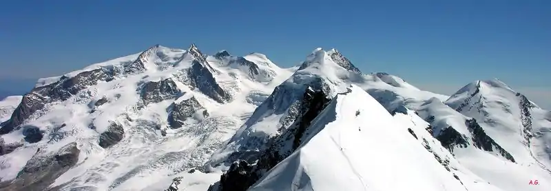
دوفوراشپیتزه (به انگلیسی: Dufourspitze) بلندترین قله تودهکوه مونته روزا است. این کوه میان کانتون وله در کشور سوئیس و پیمونت و واله دائوستا در کشور ایتالیا قرار دارد.
| دوفوراشپیتزه | |
|---|---|
| فرانسوی: Pointe Dufour, ایتالیایی: Punta Dufour | |
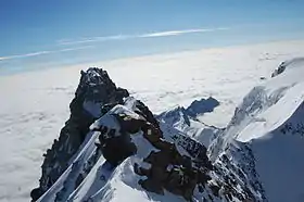 From the peak to the south-east towards Italy, the Dunantspitze in back hides the 18 metres lower Grenzgipfel (انگلیسی: Border Summit) | |
| مرتفعترین نقطه | |
| ارتفاع | ۴٬۶۳۴ متر (۱۵۲۰۳ پا) |
| ایزولاسیون | ۷۸٫۳ کیلومتر (۴۸٫۷ مایل) → M Blanc de Courmayeur[1] |
| فهرستبندی | فهرست کشورهای جهان بر پایه بلندترین نقطه Canton high point قله بسیار برجسته هفت قله دوم |
| نامگذاری | |
| ترجمه انگلیسی | Peak Dufour, Highest Peak, Large Horn |
| زبان نام | آلمانی |
| ترجمه | Peak Dufour, Highest Peak, Large Horn |
| جغرافیا | |
| کشور | سوئیس |
| کانتون | کانتون وله |
| رشتهکوه | آلپ پنین |
| نقشه توپوگرافی | Swisstopo 1348 Zermatt |
| بالا رفتن | |
| نخستین صعود | ۱ اوت ۱۸۵۵ توسط Matthäus و Johannes Zumtaugwald, Ulrich Lauener, Christopher and James Smyth, Charles Hudson, John Birkbeck و Edward Stephenson. |
| راحتترین مسیر | صخره/برف/صعود یخی |
منابع
- Retrieved from Google Earth. The nearest point of higher elevation is east of Mont Blanc.
- مشارکتکنندگان ویکیپدیا. «Dufourspitze». در دانشنامهٔ ویکیپدیای انگلیسی، بازبینیشده در ۳ اکتبر ۲۰۱۶.
This article is issued from Wikipedia. The text is licensed under Creative Commons - Attribution - Sharealike. Additional terms may apply for the media files.
