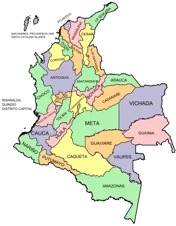
بخشهای کلمبیا
Chart بخشها
هر یک از بخشهای کلمبیا در نقشه زیر به یک مقاله مربوط لینک میشود
| بخش | پایتخت | مساحت (km²) | جمعیت | تاریخ تأسیس | |
|---|---|---|---|---|---|
| - | بوگوتا, Capital District | - | ۱٬۵۸۷ | ۷٬۱۱۷٬۹۸۴ | ۱۵۳۸-۰۸-۰۶ |
| 01 | آمازوناس | Leticia | ۱۰۹٬۶۶۵ | ۸۰٬۳۶۰ | ۱۹۹۱-۱۰-۰۵ |
| 02 | انتیوکیا | مدلین | ۶۳٬۶۱۲ | ۵٬۷۵۰٬۴۷۸ | ۱۸۲۶-??-?? |
| 03 | آرائوکا | آرائوکا | ۲۳٬۸۱۸ | ۲۸۲٬۳۰۲ | ۱۹۹۱-۰۷-۰۴ |
| 04 | آتلانتیکو | بارانکییا | ۳٬۳۸۸ | ۲٬۳۶۵٬۶۶۳ | ۱۹۱۰-۰۷-۱۴ |
| 05 | بولیوار | کارتاخنا | ۲۵٬۹۷۸ | ۲٬۲۲۹٬۹۶۷ | ۱۸۵۷-۰۶-۱۵ |
| 06 | بویاکا | تونخا | ۲۳٬۱۸۹ | ۱٬۴۱۱٬۲۳۹ | ۱۸۵۸-??-?? |
| 07 | کالداس | مانیسالس | ۷٬۸۸۸ | ۱٬۱۷۰٬۱۸۷ | ۱۹۰۵-??-?? |
| 08 | کاکئتا | فلورنسیا | ۸۸٬۹۶۵ | ۴۶۳٬۳۳۳ | ۱۹۸۲-??-?? |
| 09 | کاساناره | یوپال | ۴۴٬۶۴۰ | ۳۲۵٬۷۱۳ | ۱۹۹۱-۰۷-۰۴ |
| 10 | کائوکا | پوپایان | ۲۹٬۳۰۸ | ۱٬۳۶۳٬۰۵۴ | ۱۸۵۷-۰۶-۱۵ |
| 11 | سزار | واییدوپار | ۲۲٬۹۰۵ | ۱٬۰۵۰٬۳۰۳ | ۱۹۶۷-۱۲-۲۱[1] |
| 12 | چوکو | کیبدو | ۴۶٬۵۳۰ | ۴۱۳٬۱۷۳ | ۱۹۴۷-۱۱-۰۳ |
| 13 | کوردوبا | مونتریا | ۲۵٬۰۲۰ | ۱٬۳۹۲٬۹۰۵ | ۱۹۵۲-۰۶-۱۸ |
| 14 | کوندینامارکا | بوگوتا | ۲۴٬۲۱۰ | ۹٬۴۶۷٬۵۶۲ | ۱۸۵۷-۰۶-۱۵ |
| 15 | گواینیا | Inirida | ۷۲٬۲۳۸ | ۴۳٬۳۱۴ | ۱۹۶۳-۰۶-۱۳ |
| 16 | گواویره | سان خوسه دل گاوریاره | ۵۳٬۴۶۰ | ۱۳۳٬۲۳۶ | ۱۹۹۱-۰۷-۰۴ |
| 17 | هویلا | نیوا | ۱۹٬۸۹۰ | ۹۹۴٬۲۱۸ | ۱۹۰۵-??-?? |
| 18 | لا گواخیرا | ریوآچا | ۲۰٬۸۴۸ | ۵۲۴٬۶۱۹ | ۱۹۶۵-۰۷-۰۱ |
| 19 | ماگدالنا | سانتا مارتا | ۲۳٬۱۸۸ | ۱٬۴۰۳٬۳۱۸ | ۱۸۲۴-۰۷-۲۵ |
| 20 | متا | وییاویسنیو | ۸۵٬۶۳۵ | ۷۷۱٬۰۸۹ | ۱۹۶۰-۰۷-۰۱ |
| 21 | نارینیو | پاستو | ۳۳٬۲۶۸ | ۱٬۷۷۵٬۱۳۹ | ۱۹۰۴-۰۸-۰۶ |
| 22 | نورته د سانتاندر | کوکوتا | ۲۱٬۶۵۸ | ۱٬۴۹۳٬۹۳۲ | ۱۹۱۰-۰۷-۲۵ |
| 23 | پوتومایو | موکوآ | ۲۴٬۸۸۵ | ۳۷۸٬۴۸۳ | ۱۹۹۱-??-?? |
| 24 | کیندیو | آرمنیا | ۱٬۸۴۵ | ۶۱۳٬۳۷۵ | ۱۹۶۶-۰۷-۰۱ |
| 25 | ریسارالدا | پریرا | ۴٬۱۴۰ | ۱٬۰۲۴٬۳۶۲ | ۱۹۶۶-۰۷-۰۱ |
| 26 | سن آندرس، پروویدنسیا | ایسلا ده سان آندرس | ۵۲ | ۸۳٬۴۹۱ | ۱۹۹۱-۰۷-۰۴ |
| 27 | سانتاندر | بوکارامانگا | ۳۰٬۵۳۷ | ۲٬۰۸۵٬۰۸۴ | ۱۸۵۷-۰۵-۱۳ |
| 28 | سوکره | سینسلخو | ۱۰٬۹۱۷ | ۸۶۸٬۶۴۸ | ۱۹۶۶-۰۸-۱۸ |
| 29 | تولیما | ایباگه | ۲۳٬۵۶۲ | ۱٬۳۱۲٬۹۷۲ | ۱۸۸۶-۰۸-۰۴ |
| 30 | بایه دل کائوکا | کالی | ۲۲٬۱۴۰ | ۴٬۵۲۴٬۶۷۸ | ۱۹۱۰-۰۴-۱۶ |
| 31 | واوپس | میتو | ۵۴٬۱۳۵ | ۳۳٬۱۵۲ | ۱۹۹۱-۰۷-۰۴ |
| 32 | ویچادا | Puerto Carreño | ۱۰۰٬۲۴۲ | ۹۷٬۲۷۶ | ۱۹۹۱-۰۷-۰۵ |
- پایتخت کشور، بوگوتا در برآورد برای کوندینامارکا شامل شده .
نگارخانه نقشهها
- نقشه بخشهای کلمبیا همراه names overlaid.
 نقشه کلمبیا همراه بخشهای numbered departments
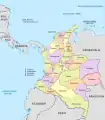 نقشه سیاسی کلمبیا
Territorios indígenas
Colombia's indigenous territories are created by agreement between the government and indigenous communities. In cases where indigenous territories covering more than one department or municipality, local governments jointly administer the indigenous councils such territories, as set out in Articles ۳۲۹ و ۳۳۰ of the Constitution of Colombia. Also indigenous territories can have character of local authority if they meet the requirements of the law. Indigenous territories in Colombia are mostly in the departments of Amazonas, Cauca, La Guajira, Guaviare and Vaupés.[2]
پانویس
- "History of Cesar" (به Spanish). Agustin Codazzi Geographic Institute. Archived from the original on 24 October 2003. Retrieved 6 September 2014.
- Colombiaya.com (ed.). "Division Política de Colombia". Archived from the original on 4 April 2013. Retrieved 6 September 2014.
منابع
- مشارکتکنندگان ویکیپدیا. «Departments of Colombia». در دانشنامهٔ ویکیپدیای انگلیسی، بازبینیشده در ۶ سپتامبر ۲۰۱۴.
This article is issued from Wikipedia. The text is licensed under Creative Commons - Attribution - Sharealike. Additional terms may apply for the media files.
