آترتون، کالیفرنیا
آترتون (به انگلیسی: Atherton) شهری در شهرستان سن ماتئو ایالت کالیفرنیا است که در سرشماری سال ۲۰۱۰ میلادی، ۶۹۱۴ نفر جمعیت داشته است.[7][8]
آترتون | |
|---|---|
| Town of Atherton | |
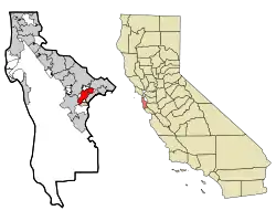 Location in شهرستان سن ماتئو و ایالت کالیفرنیا | |
| مختصات: ۳۷°۲۷′۳۱″ شمالی ۱۲۲°۱۲′۰″ غربی[1] | |
| کشور | |
| ایالت | |
| شهرستان | سن ماتئو |
| Incorporated | September 12, 1923[2] |
| وجه تسمیه | Faxon Dean Atherton[2] |
| مدیریت | |
| • نوع | شهر |
| • شهردار | Bill Widmer |
| • City council | Council Members
|
| • State Assembly | Rich Gordon (د) (21st) |
| • State Senate | Joe Simitian (د) (11th) |
| • مجلس نمایندگان | انا اشو (د) (14th) |
| مساحت | |
| • کل | ۵٫۰۴۹ مایل مربع (۱۳٫۰۷۶ کیلومتر مربع) |
| • خشکی | ۵٫۰۱۷ مایل مربع (۱۲٫۹۹۳ کیلومتر مربع) |
| • آب | ۰٫۰۳۲ مایل مربع (۰٫۰۸۲ کیلومتر مربع) 0.63% |
| بلندی | ۵۹ پا (۱۸ متر) |
| جمعیت (2010) | |
| • کل | ۶٬۹۱۴ |
| • تراکم | ۱۴۰۰/مایل مربع (۵۳۰/کیلومتر مربع) |
| اداره آمار آمریکا | |
| منطقه زمانی | یوتیسی -۸ (PST) |
| • تابستان (ساعت تابستانی) | یوتیسی -۷ (PDT) |
| زیپکد[5] | 94027 |
| پیششماره تلفن[6] | 650 |
| GNIS feature ID[1] | 1657960 |
| وبگاه | |
نگارخانه


جستارهای وابسته
منابع
- "Feature Detail Report for: Atherton". Geographic Names Information System. سازمان نقشهبرداریهای زمینشناسی آمریکا. Retrieved 2009-08-21.
- "Atherton History". Town of Atherton. 2007-04-27. Archived from the original on 12 September 2009. Retrieved 2009-08-21.
- "Agendas/Reports/Minutes - City Council". Town of Atherton. 2008-12-30. Archived from the original on 28 July 2012. Retrieved 2009-08-21.
- «U.S. Census». بایگانیشده از اصلی در ۲۰ فوریه ۲۰۱۱. دریافتشده در ۱۷ مه ۲۰۱۲.
- "USPS - ZIP Code Lookup - Search By City". United States Postal Service. Retrieved 2009-08-21.
- "NANP Administration System". North American Numbering Plan Administration. Archived from the original on 22 September 2010. Retrieved 2009-08-21.
- "American FactFinder". United States Census Bureau. Retrieved 6 May 2012.
- "United States Census Bureau". United States Census Bureau. Retrieved 6 May 2012.
شهرداریها و جوامع شهرستان سن ماتئو، کالیفرنیا، ایالات متحده | ||
|---|---|---|
مرکز شهرستان: Redwood City | ||
| فهرست شهرهای کالیفرنیا |
|  شهرستان سن ماتئو map |
| حوزه سرشماری | ||
| محدوده ثبتنشده |
| |
| شهر متروکهs |
| |
This article is issued from Wikipedia. The text is licensed under Creative Commons - Attribution - Sharealike. Additional terms may apply for the media files.
